Planning For Main Streets
The Planning for Main Streets project is a regional effort led by SCAG to reimagine state highway corridors that double as community main streets. The project focuses on four corridors—State Route (SR) 1, SR 18, SR 39, and SR 86 in Los Angeles, San Bernardino, Orange, and Imperial counties—and aims to transform these roads into people-centered places that balance transportation needs with community well-being. Through this initiative, SCAG and its partners will address transportation inequities, improve safety and mobility for all users, and align infrastructure with everyday needs of residents, workers, and visitors.
This project includes planning, design, and community engagement to create safer, more accessible, and vibrant streetscapes. By collaborating with local jurisdictions, community organizations, and the public, the project will identify feasible improvements and implementation strategies that promote equity, health, and sustainability in the region.
Project Goals
The goals of the project are to:
Improve safety and accessibility for all modes of transportation.
Enhance quality of life in equity-priority communities.
Align state highway design with local community needs.
Foster local support and ownership of project outcomes.
Develop grant-ready design concepts to support future funding opportunities.
Contact
For more information on the study, please contact us here.
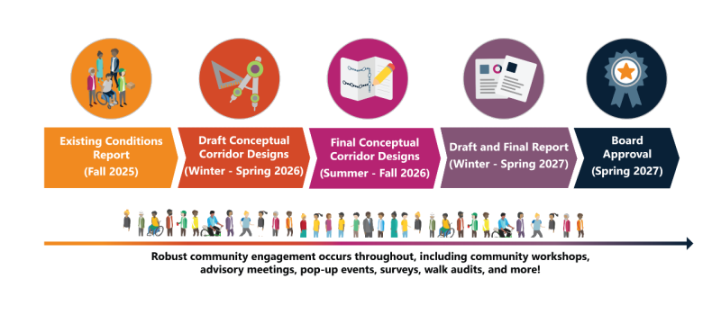
Study Work
Over the two-year study period (2025-2027), SCAG and its partners will be working on:
Understanding the Corridors
The project begins with a comprehensive review of existing conditions on each corridor, assessing traffic patterns, sidewalk and bike facility availability, transit access, crash data, and environmental conditions. The team will also review relevant planning documents to ensure alignment with local and state goals.
Community Engagement
Engagement will include walk audits, surveys, workshops, and pop-up events using tools like the Go Human Kit of Parts. Community advisory committees and technical advisory committees will guide each phase, ensuring that the designs reflect local values and priorities.
Design and Evaluation
Draft design concepts will be developed for each corridor, taking into account community input and technical feasibility. Designs will propose new street configurations that better serve pedestrians, bicyclists, and transit riders while accommodating vehicle travel. The concepts will be refined through workshops and evaluated using clear criteria related to safety, mobility, equity, and sustainability.
Final Recommendations and Reporting
The final stage will involve preparing grant-ready materials, fact sheets, and a comprehensive report for each corridor. These will include detailed conceptual designs, cost estimates, and potential funding sources. The final concepts will be presented to local governing bodies and SCAG committees for feedback and approval, setting the stage for future implementation.
Study Corridors
- State Route 1 From Lomita to Long Beach
State Route 1 From Lomita to Long Beach
Image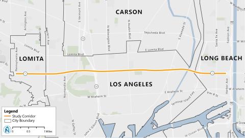
Study Area: State Route 1 from Pennsylvania in the city of Lomita to Harbor Avenue/I-70 ramps in city of Long Beach, approximately 6.5 miles.
State Route (SR) 1 is one of the busiest corridors in Los Angeles County due to its proximity to I-70, SR 103, I-110, and the ports of Los Angeles and Long Beach, which all generate high vehicular and freight traffic in the area. Multiple transit services, such as the Los Angeles County Metropolitan Transportation Authority, Long Beach Transit, Los Angeles Department of Transportation, and Torrance Transit, operate along the study corridor. SR 1 also links the downtown areas of Lomita, Harbor City, and Wilmington and runs through the industrial zones of Wilmington and Long Beach as well as a variety of residential areas and businesses.
City Partners
Image Image
Image Image
Image
Transportation Agency Partners
Image Image
Image Image
Image Image
Image Image
Image Image
Image
- State Route 18 in San Bernardino
State Route 18 in San Bernardino
Image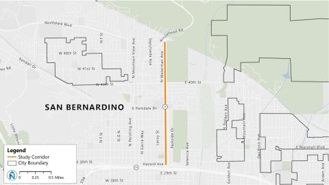
Study Area: State Route 18 from Arrowhead Road to 30th Street in San Bernardino, approximately two miles.
State Route (SR) 18 is a gateway to two major recreation destinations, Lake Arrowhead and San Bernardino National Forest, which draw many visitors. The corridor is used every day by local community members traveling to and from their homes, schools at Parkdale Drive, businesses along 40th Street, and SR 210.
City Partners
Image
Transportation Agency Partners
Image Image
Image
- State Route 39 from Stanton to Westminster
State Route 39 from Stanton to Westminster
Image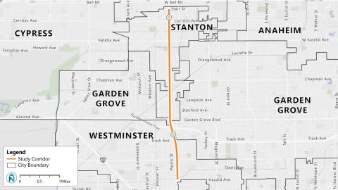
Study Area: State Route 39 from Starr Street in Stanton to Hazard Avenue in Westminster, approximately 4.5 miles.
State Route (SR) 39 is a major corridor in Orange County with high traffic volumes due to its multiple strip malls, office parks, and intersection with SR 22. The corridor is also served by several Orange County Transportation Authority bus routes.
City Partners
Image Image
Image
Transportation Agency Partners
Image Image
Image
- State Route 86 (Main St/1st St/Brawley Ave) in Brawley
State Route 86 (Main St/1st St/Brawley Ave) in Brawley
Image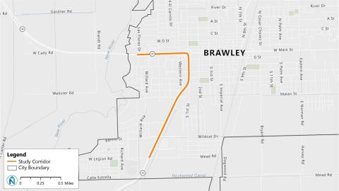
Study Area: State Route 86 from Las Flores Drive to Legion Road in Brawley, approximately two miles.
SR 86 is a gateway to Brawley’s Main Street, the city’s downtown core, lined with many businesses. Residents use this road to travel between their homes and surrounding communities. The Brawley Circulator and Imperial Valley Transit operate in areas adjacent to the corridor.
City Partners
Image
Transportation Agency Partners
Image Image
Image Image
Image
Get Involved
Community engagement began fall 2025. There are several opportunities to provide input:
Workshops
In April and May, SCAG will host online workshops to introduce the local projects, review existing conditions, and gather community input. Your feedback will help inform corridor priorities and potential recommendations to improve safety, mobility, and placemaking.
Register online using the following links to attend one or more workshops.
Workshop Dates
Each workshop will be held from 6-7 p.m.
- San Bernardino (SR-18): Monday, April 13
- Lomita (SR-1): Thursday, April 16
- Los Angeles (SR-1): Monday, April 20
- Long Beach (SR-1): Monday, April 27
- Westminster (SR-39): Thursday, April 30
- Stanton (SR-39): Monday, May 4
- Brawley (SR-86): Monday, May 11
Surveys
Thank you for participating in the study corridor surveys, which were open from December 2025 to February 2026. The project team is analyzing results and will share updates soon.
- SR 1 (Los Angeles County)
- Community Walk Audit
- Long Beach
- Date: Dec. 4, 2025
- Time: 9 a.m.
- Location: Winchell's Donut House (1695 W. Pacific Coast Hwy., Long Beach, CA 90810)
- Walk Audit Summary
- Los Angeles
- Date: Dec. 4, 2025
- Time: 3 p.m.
- Location: Banning Recreation Center
- Walk Audit Summary
- Lomita
- Date: Dec. 3, 2025
- Time: 8:10 a.m.
- Location: Miss Donut & Bakery (1871 Pacific Coast Hwy., Lomita, CA 90717)
- Walk Audit Summary
- Long Beach
- Community Walk Audit
- SR 18 (San Bernardino County)
- Community Walk Audit
- Date: Nov. 18, 2025
- Time: 3:30 p.m.
- Location: Wildwood Park (parking lot off N. Waterman Ave. & E. 40th St., Brawley, CA 92404)
- Walk Audit Summary
- Community Walk Audit
- SR 39 (Orange County)
- Community Walk Audit
- Stanton
- Date: Dec. 2, 2025
- Time: 10 a.m.
- Location: City of Stanton Corporate Yard (8100 Pacific St., Stanton, CA 90680)
- Walk Audit Summary
- Westminster
- Date: Dec. 5, 2025
- Time: 9 a.m.
- Location: Bob's Burgers (13891 Beach Blvd., Westminster, CA 92683)
- Walk Audit Summary
- Stanton
- Community Walk Audit
- SR 86 (Imperial County)
- Community Walk Audit
- Date: Dec. 11, 2025
- Time: 8:30 a.m.
- Location: Witter Elementary School (corner of S. 1st St. and K St., Brawley, CA 92227)
- Walk Audit Summary
- Community Walk Audit
Project Timeline
Resources
Check out the study’s resources when completed.